


corniche betpaumes

lablaquiere
User
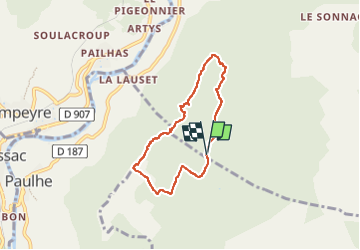

Length
5.9 km

Max alt
843 m

Uphill gradient
67 m
Km-Effort
6.8 km

Min alt
804 m

Downhill gradient
68 m
Boucle
Yes
Creation date :
2022-07-11 15:38:54.455
Updated on :
2022-07-11 17:27:01.818
1h25
Difficulty : Medium

FREE GPS app for hiking
 SityTrail
IGN / Geographical institutes
SityTrail Plus
The world is yours!
About
Trail Walking of 5.9 km to be discovered at Occitania, Aveyron, La Cresse. This trail is proposed by lablaquiere.
Positioning
Country:
France
Region :
Occitania
Department/Province :
Aveyron
Municipality :
La Cresse
Location:
Unknown
Start:(Dec)
Start:(UTM)
510739 ; 4889177 (31T) N.
Comments